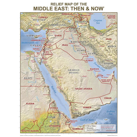
Middle East Relief Map Then & Now Wall Chart Laminated
Original price
$0
Original price
$14.99
-
Original price
$14.99
Original price
Current price
$14.99
$14.99
-
$14.99
Current price
$14.99
SKU 4039L
This large, classroom-size "Middle" Relief Map is unlike any other Middle East map of its kind! Easily see where Bible places are located today with its red "Then and Now" boundary lines—and enjoy its stunning detailed relief of key mountains, valleys, rivers, and deserts within the Middle East. Perfect for Bible studies, Bible class lessons, homeschool curriculum, and to display in your classroom, church hallway, or office.
See the boundaries of Israel, Egypt, Assyria and Babylonia during Bible times — and how they compare to the modern-day location of Iran, Iraq, Egypt, Turkey, and Israel.
Usually the information included on this map is shown on two separate maps—but for the first time ever Rose has combined this useful information onto one Bible wall map. Red print shows the major cities and boundaries of modern countries. Laminated for durability. Write on, wipe off with water soluble markers.
Size: 19.5" x 26", heavy chart paper.
Bible Places Identified on this "Then and Now Bible" Map:
Bible Map of Israel, Canaan, Egypt, Cush, Sheba, Armenia
Bible Map of the Hittites, Hurrians
Bible Map of Nile River, Sea of Galilee, Red Sea, Jordan River
Bible Map of Assyria, Babylonia, Sumer, Elam, Persia and Media
Modern-Day Places Identified on this "Then and Now" Bible Map
Modern map of Israel, Egypt, Lebanon, Jordan, Syria, Saudi Arabia
Modern map of Iran, Iraq, United Arab Emirates, Yemen, Oman, Qatar, Bahrain, and Kuwait
Modern map of Sinai Peninsula, Gaza Strip, Golan Heights, West Bank
